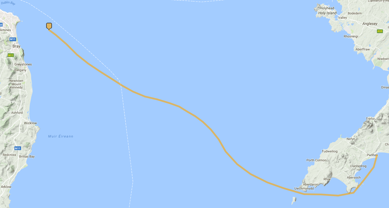
Unfortunately, I forgot to turn the Navtex logger on when we were alongside the pontoon, so the log starts somewhere out past the Burford Buoy. More reason to write the code for the ESP8266 and build my data logger.
| Day | Day/time (IST) | Latitude | Longitude | SoG (knots) | Heading (True) |
| 2018-07-06 | 2144 | 53° 14.811′ N | 005° 57.360′ W | 5 | 128 |
| 2201 | 53° 13.984′ N | 005° 55.466′ W | 4.9 | 126 | |
| 2230 | 53° 12.391′ N | 005° 52.442′ W | 5 | 136.5 | |
| 2301 | 53° 10.583′ N | 005° 49.360′ W | 5 | 129.5 | |
| 2330 | 53° 09.064′ N | 005° 46.156′ W | 4.8 | 127 | |
| 2018-07-07 | 0001 | 53° 07.647′ N | 005° 42.721′ W | 4.8 | 122 |
| 0030 | 53° 06.484′ N | 005° 39.573′ W | 4.5 | 127 | |
| 0101 | 53° 05.239′ N | 005° 36.372′ W | 4.5 | 117 | |
| 0130 | 53° 04.233′ N | 005° 33.414′ W | 4.2 | 118 | |
| 0201 | 53° 03.394′ N | 005° 29.990′ W | 4.5 | 107 | |
| 0230 | 53° 02.920′ N | 005° 26.470′ W | 4.6 | 100 | |
| 0301 | 53° 02.272′ N | 005° 22.878′ W | 4.3 | 104.5 | |
| 0330 | 53° 01.664′ N | 005° 20.177′ W | 3.2 | 125 | |
| 0401 | 53° 00.772′ N | 005° 17.810′ W | 3.2 | 122.5 | |
| 0430 | 53° 00.028′ N | 005° 15.653′ W | 3.2 | 120 | |
| 0501 | 52° 59.053′ N | 005° 13.446′ W | 3.6 | 131 | |
| 0530 | 52° 57.725′ N | 005° 11.152′ W | 4.1 | 138.5 | |
| 0601 | 52° 56.040′ N | 005° 08.902′ W | 4.5 | 147 | |
| 0630 | 52° 53.929′ N | 005° 06.898′ W | 5.3 | 126 | |
| 0701 | 52° 51.738′ N | 005° 03.652′ W | 5.9 | 126 | |
| 0730 | 52° 50.053′ N | 004° 59.809′ W | 6.1 | 117 | |
| 0801 | 52° 48.620′ N | 004° 55.068′ W | 6.6 | 113 | |
| 0830 | 52° 47.595′ N | 004° 50.412′ W | 6.1 | 107 | |
| 0901 | 52° 46.572′ N | 004° 44.483′ W | 7.7 | 97 | |
| 0930 | 52° 46.506′ N | 004° 39.631′ W | 5.4 | 87 | |
| 1001 | 52° 46.335′ N | 004° 34.768′ W | 5.8 | 90 | |
| 1030 | 52° 46.832′ N | 004° 30.436′ W | 5.1 | 56.5 | |
| 1101 | 52° 49.036′ N | 004° 27.443′ W | 5.6 | 36.5 | |
| 1130 | 52° 51.255′ N | 004° 24.699′ W | 5.7 | 38 | |
| 1201 | 52° 53.240′ N | 004° 23.718′ W | 3.1 | 254 |